Hushe Valley – Gateway to the Karakoram Giants!
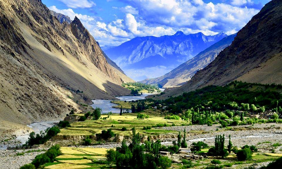
Hushe Valley, located in Ghanche District of Baltistan, is one of the last frontiers of adventure in Pakistan. Surrounded by 7000m+ peaks, including Masherbrum, Laila Peak, K6, and K7, this valley offers dramatic landscapes, alpine villages, glacial rivers, and a starting point for world-famous treks like Gondogoro La and Masherbrum Basecamp.
Unlike mainstream destinations, Hushe remains peaceful, authentic, and deeply rooted in Balti culture, attracting climbers, photographers, and nature lovers seeking raw beauty.
Why Visit Hushe Valley?
| Feature | Description |
|---|---|
| 🏔️ Mountains | Surrounded by Karakoram peaks – Masherbrum, Laila Peak, K6, K7 |
| 🧗 Trekking Hub | Gateway to Gondogoro La, Masherbrum BC, Charakusa Glacier |
| 🌲 Untouched Nature | Lush summer meadows, glacial rivers, hanging glaciers |
| 🧕 Balti Culture | Quiet villages, stone homes, warm hospitality |
| 🐐 Wildlife & Livestock | Mountain goats, yaks, and shepherd trails |
| 📷 Photography Paradise | Jagged peaks, reflections, stars, and village life |
Routes to Hushe Valley
Location & Accessibility
District: Ghanche, Gilgit-Baltistan
Elevation: ~3,050 meters (10,000 ft)
From Skardu: ~140 km (~6 hours by 4×4 vehicle)
Route: Skardu → Khaplu → Machulo → Hushe
Last Village: Hushe is the last human settlement in this part of the valley
River: Fed by glaciers, Hushe River runs through the valley
💡 Roads are narrow and rough in sections; travel with a 4×4 and experienced driver.
Top Treks & Trails from Hushe
| Trek | Duration | Highlights |
|---|---|---|
| 🏞️ Gondogoro La Trek | 8–12 days | Connects to K2 Basecamp via high-altitude pass (~5,585m) |
| 🏕️ Masherbrum Basecamp | 3–4 days | Close-up view of K1 (7,821m) – one of the hardest peaks to climb |
| 🧊 Charakusa Glacier Trek | 4–6 days | Towering granite walls, technical climbing zone |
| 🏔️ Laila Peak Basecamp | 2–3 days | Near-perfect pyramid mountain — highly photogenic |
| 🌿 Aling Valley Hike | Day hike | Beautiful alpine meadow for light trekkers |
Best Time to Visit
| Season | What to Expect |
|---|---|
| June – August | Best for trekking; green, warm days and cool nights |
| September – October | Autumn colors, quieter trails |
| November – April | Closed due to snow; dangerous and inaccessible |
Photography Highlights
| Spot | Subject |
|---|---|
| 🏞️ Masherbrum View | Sunrise/sunset views from camp or village |
| 🌌 Night Sky | No light pollution — stunning Milky Way shots |
| 🐐 Shepherd Trails | Cultural and documentary-style photos |
| ⛏️ Trekkers on Glacier | Capture the human scale next to massive ice fields |
Local Food
Try local dishes like:
Chapshuro (meat-filled bread)
Sharbat (dried apricot juice)
Trout Fish (fresh from local rivers)
Butter tea & organic yogurt
Must-know things!
- Sleeping Mask & Ear Plugs: Warm Shawl/Lightweight Jacket.
- Gadgets & ChargersBook & Notepad.
- Mints, Sanitizer, Wet Wipes & Tissue paper.
- Toiletries.
- Snacks.
- Hiking boots/Sturdy Joggers.
- Cargo Pants/Hiking Trouser.
- Hat, Sunglasses, Sunblock.
- Refillable Water Bottle.
- Snacking Bars/Dry Fruits.
Traveler Tips
Fuel Up in Gupis or Gilgit – no petrol stations in Golaghmuli
Mobile Network: Limited; only SCOM works in some areas
Permits: No NOC needed for Pakistani tourists. Foreigners might need NOC from Gilgit.
Weather Gear: Even in summer, nights are cold – bring layers
Altitude Sickness: Stay hydrated, ascend gradually